zoning knowledge
What Is a Regional Node? Forsyth County’s Three Biggest Growth Centers, Mapped
A regional node is one of three places Forsyth County’s comprehensive plan has picked for its most intense development: the biggest commercial centers, the tallest office buildings, and the most jobs. The three are the McFarland and Shiloh Road node at the Fulton County line, the South GA 400 and Highway 141 node around Peachtree Parkway, and the Hammond’s Crossing node where GA 400 meets Browns Bridge Road and Keith Bridge Road north of Cumming. Everything else in the county is meant to step down from there.
Below is what a node is, how regional nodes differ from the smaller community and neighborhood nodes, and a close look at each of the three, with the county’s own maps.
Where this comes from
The Foster Forsyth Comprehensive Plan is the county’s long range guide for growth. The current version was adopted October 20, 2022 and runs through 2042, and the county has amended its Community Character Map since then, most recently on April 17, 2025. Everything in this post comes from that amended plan.
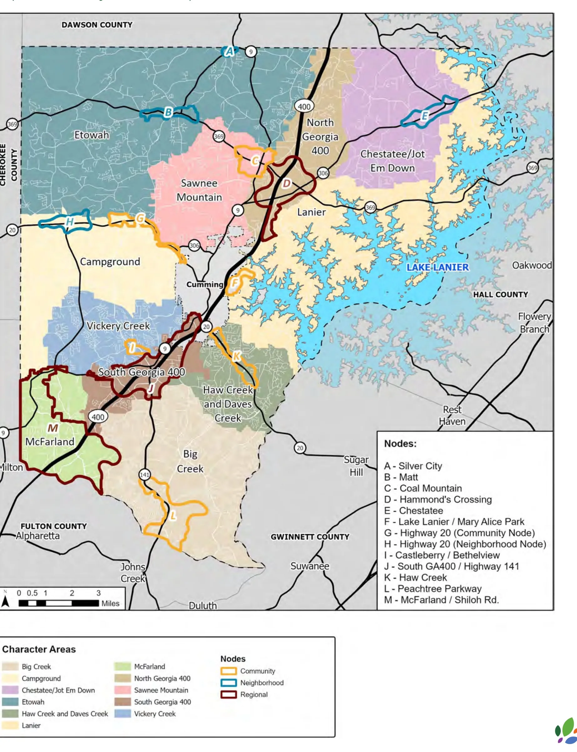
The plan splits the county into 11 character areas, each with its own vision, from rural Etowah in the northwest to the job centers along GA 400. Inside those character areas it marks smaller circles called nodes. The plan describes nodes as the specific locations for higher intensity development within a character area, the “destination hubs for community activity.”
The key policy in one sentence, from Section 4.1: “Future commercial development should primarily be located within identified development nodes. Outside of these nodes, commercial uses should be limited to designated commercial corridors.”
Regional, community and neighborhood nodes
The county has 13 nodes in three sizes.
| Type | What the plan says it is for | Nodes |
|---|---|---|
| Regional | Serves the region and the county as a whole. Larger developments and facilities, the highest concentration of jobs and commercial, and high density residential as part of mixed use | McFarland/Shiloh Road, South GA 400/Highway 141, Hammond’s Crossing |
| Community | Smaller commercial centers with office and residential for a local market. Higher density housing belongs only inside these nodes and some areas right around them, subject to Board approval | Peachtree Parkway, Haw Creek, Castleberry/Bethelview, Lake Lanier/Mary Alice Park, Highway 20, Coal Mountain |
| Neighborhood | Neighborhood shopping clustered at prominent intersections, with a “small town core” feel | Highway 20, Chestatee, Matt, Silver City |
All three types sit on major roads. The difference is reach. A regional node is built to pull people in from outside Forsyth County. A neighborhood node is built for the subdivisions around it.
The plan is blunt about which node gets the most: “Generally, regional nodes should accommodate the most intense uses and community nodes should be more modest in scale.” That is also where the county expects its newer mixed use districts to land. The Mixed Use Center District (MCD) and Master Planned District (MPD) are “primarily allowed within the regional, community, and neighborhood nodes,” and are meant to produce vertical and horizontal mixed use in regional and community nodes.
1. McFarland/Shiloh Road Regional Node
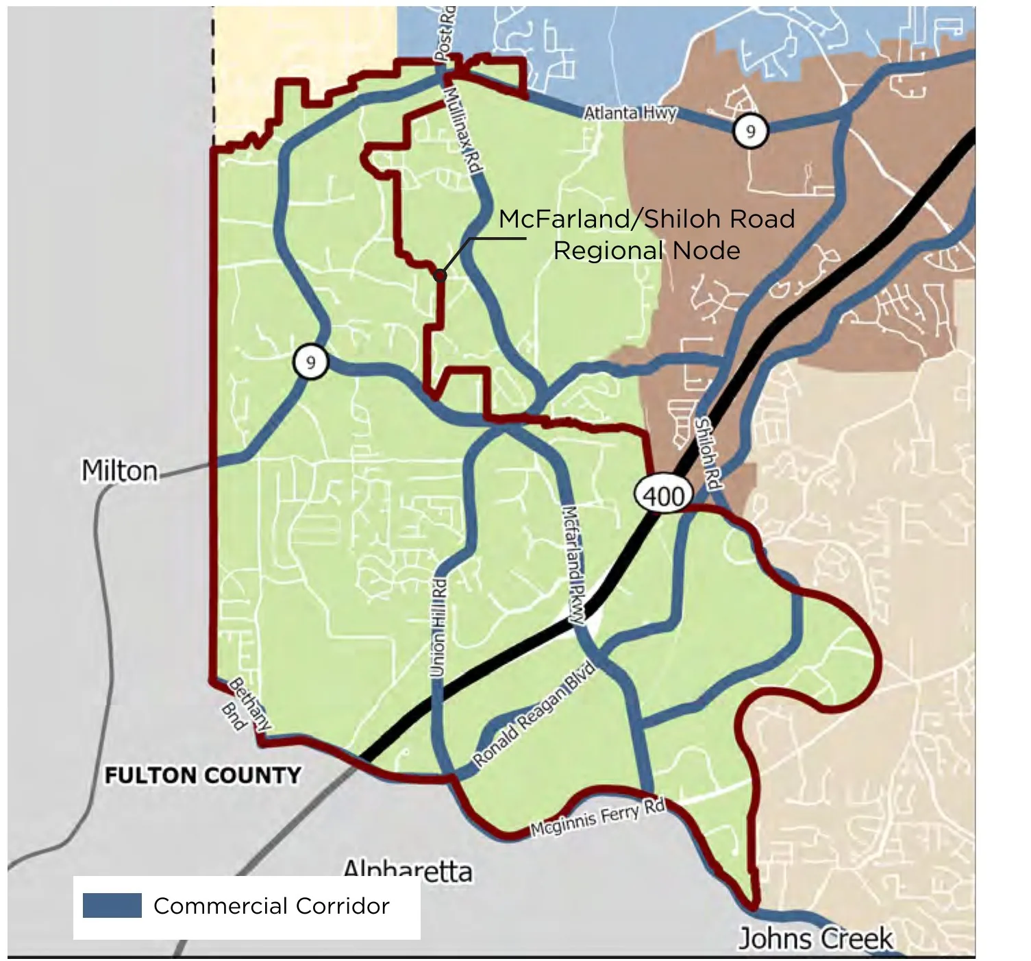
Where it is: The southwest corner of the county along GA 400, from the Fulton County line north through McFarland Parkway and the industrial land along Shiloh Road. It takes in Atlanta Highway (SR 9), Ronald Reagan Boulevard, McGinnis Ferry Road and Union Hill Road.
What it is today: The plan describes this node as “largely industrial,” paired with commercial along the main roads, with single family neighborhoods of all ages just outside it.
What the county wants: Office and employment centers, with the most intensity along GA 400, plus housing tied directly to those jobs to take some pressure off traffic. Residential density should be highest near the job centers and step down to the north and west.
How tall: Up to 6 stories for office and 5 for mixed use. The plan allows up to 9 stories for office inside the subareas the development code maps for it. In the code’s terms that works out to 80 feet for office, and 125 feet in one mapped portion, as we covered in our commercial zoning post.
What zoning fits: This is the most permissive node in the county. The plan lists RES1 through RES4, every commercial district (NS, UV, CBD, HB, HC), every office district (BP, O&I, OR, OCMS), both M1 and M2 industrial, A1, AG RES, and the MPD, MCD and MRD specialty districts. It is the only regional node where new vehicle sales, vehicle service and 1 to 2 story exterior access self storage are all listed as appropriate. Open storage yards fit here too.
One condition worth knowing: Higher density residential is permitted only as part of mixed use with active commercial on the ground floor, and single family projects should save the main road frontage and corners for commercial or office.
This node also has a history. The 2022 plan update found that a 2021 adjustment had grown the node until it covered almost the entire McFarland character area. The county pulled it back, moved the northwest parcels into the Campground character area and the eastern parcels into Big Creek. The plan’s work program schedules a subarea study for the McFarland character area in 2026, so this is the node most likely to see its rules refined next.
2. South GA 400/Highway 141 Regional Node
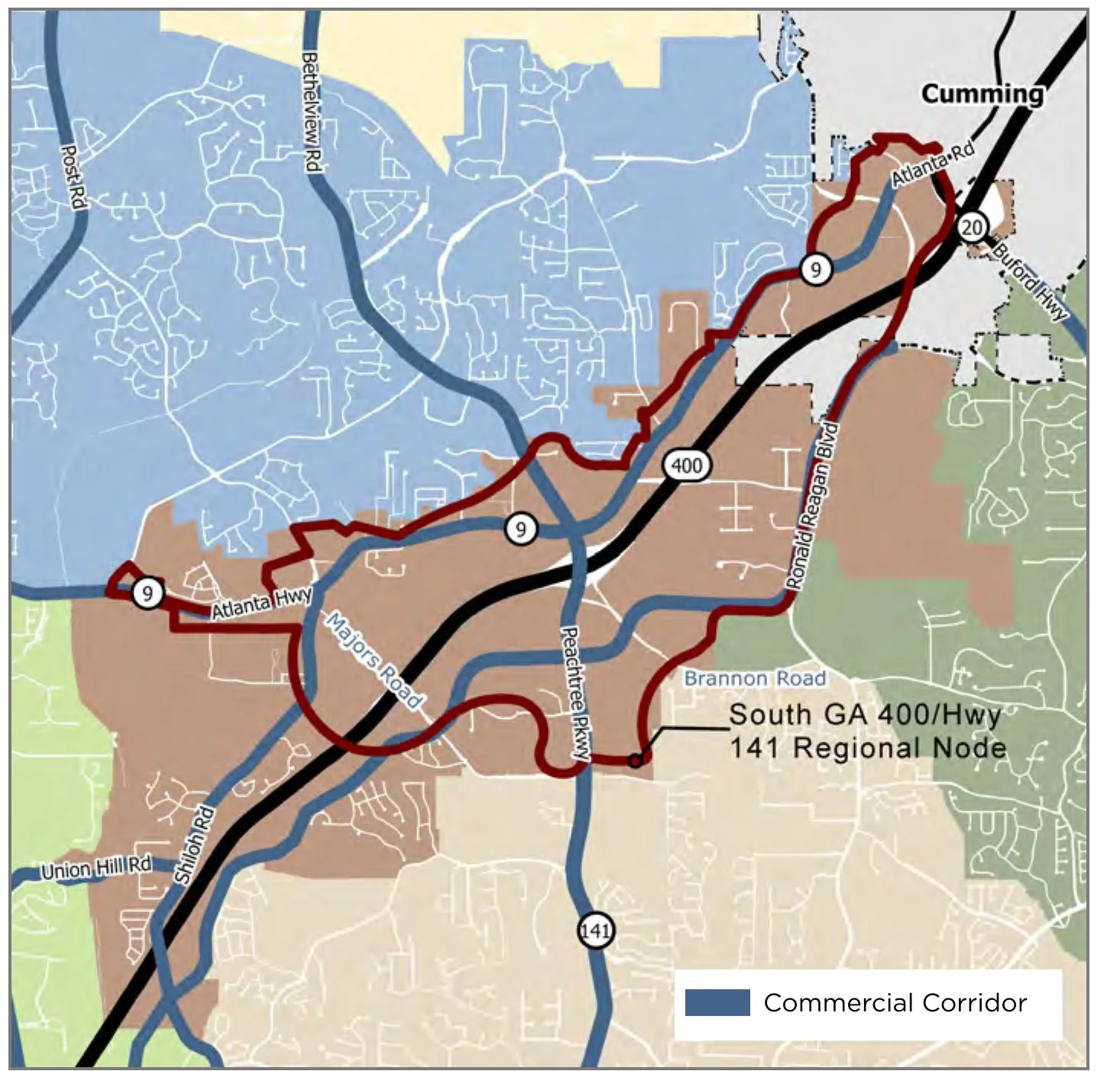
Where it is: Both sides of GA 400 from around Atlanta Highway (SR 9) north toward the City of Cumming, wrapped around the Peachtree Parkway (SR 141) interchange. The Collection at Forsyth sits at GA 400 and Highway 141, near the center of the character area. Bethelview Road, Ronald Reagan Boulevard, Shiloh Road and Union Hill Road are the commercial corridors around it.
What it is today: A mix of industrial and commercial with undeveloped tracts scattered along the corridor. The Vulcan quarry sits at the north end of the character area.
What the county wants: The plan’s goal is “a mixed use node with employment opportunities at the crossroads of GA 400 and Highway 141.” Larger scale office and business uses, town center development with a regional draw, and housing that plays a secondary role inside those town centers.
How tall: Up to 4 stories for office and mixed use. That makes it the most restrained of the three on height, even though it sits on the busiest interchange.
What zoning fits: This is the most commercial and least residential node. No standalone residential district is listed for the node, and neither is A1 or AG RES. Housing comes in through mixed use and the specialty districts. Inside the node the plan lists NS, CBD and HC commercial, all four office districts, M1, and MPD, MCD and MRD. UV, HB and M2 are not listed for the node.
Rules that stand out: Structured parking should be required in mixed use and higher density projects. New vehicle sales are appropriate on the corridors in the character area but specifically not inside the node, and multi story self storage belongs in the character area outside the node.
3. Hammond’s Crossing Regional Node
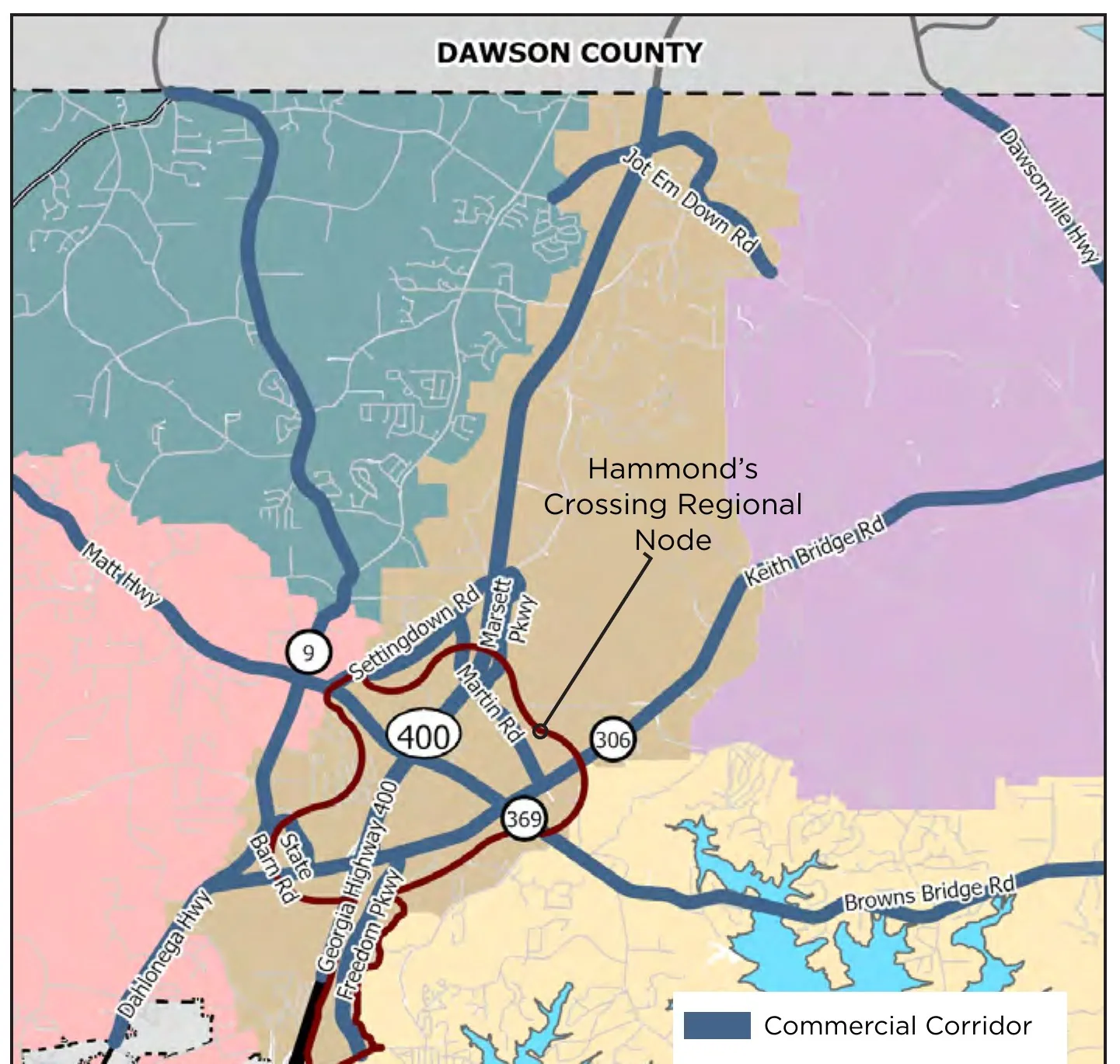
Where it is: North of Cumming where GA 400 crosses Browns Bridge Road (SR 369) and Keith Bridge Road (SR 306), with Martin Road, Settingdown Road and Marsett Parkway running through it and Dahlonega Highway (SR 9) at its west edge. It is the only regional node in north Forsyth.
What it is today: The surrounding North GA 400 character area is mostly undeveloped and agricultural land, large lot homes, and commercial at the big intersections. Of the three nodes, this one has the most open land left.
What the county wants: A town center scale node focused on employment, with higher density housing and mixed use inside the node. Outside it, the plan wants lower intensity, smaller commercial areas and larger residential lots, and it wants sites outside the node designed around the existing trees, landforms and topography.
How tall: Up to 6 stories for non residential and mixed use, and up to 4 stories for residential. The development code puts that at 80 feet for non residential and mixed use.
What zoning fits: Inside the node the plan lists RES3 as the only standard residential district, along with NS, UV, CBD and HC commercial, all four office districts, M1 and M2, AG RES, and MPD, MCD and MRD. HB and A1 are not listed for the node. In the surrounding character area the plan says large lot subdivisions under A1 are “strongly encouraged and are considered fully compliant.”
Rules that stand out: Multi family should mainly be built in mixed use buildings with a non residential use on the ground floor. Light industrial belongs along the corridors next to GA 400 and must be screened. Vehicle service is appropriate inside the node, but new vehicle sales, open storage yards and multi story self storage are pushed to the character area outside it. The plan’s work program also calls for a subarea study of the North GA 400 corridor.
The three side by side
| McFarland/Shiloh Road | South GA 400/Hwy 141 | Hammond’s Crossing | |
|---|---|---|---|
| Location | GA 400 at the Fulton line, McFarland Pkwy, Shiloh Rd | GA 400 at Peachtree Pkwy (SR 141) | GA 400 at SR 369 and SR 306 |
| Main role | Office, jobs, industry | Regional retail and office town center | Jobs focused town center |
| Max height in plan | 6 stories office (9 in mapped subareas), 5 mixed use | 4 stories office and mixed use | 6 stories non residential, 4 residential |
| Standard residential districts listed | RES1 to RES4 | None | RES3 |
| Industrial districts listed | M1, M2 | M1 | M1, M2 |
| New vehicle sales in the node | Yes | No | No |
What a node means for a landowner
A node designation is not zoning. Land inside a regional node is still zoned whatever it is zoned today, often A1, and it still has to go through a rezoning to get to CBD, MPD or anything else. What the node changes is the argument. County staff and the Board of Commissioners use the character map and these tables when they review a rezoning, so an application that lines up with the node’s listed districts starts from a position the plan already supports. An application that asks for the same thing two miles outside the node has to argue against the plan.
That matters more right now than it usually would. The residential side of the code has been on pause under the county’s residential moratorium, while commercial and office rezonings have kept moving. In our August 2026 zoning report, every rezoning filed that month asked for CBD. The regional nodes are where the plan most clearly supports that kind of request, and where the mixed use districts that carry apartments and townhomes are meant to go. Two of those districts, MRD and MCD, are also among the three the county is still accepting residential applications for while the moratorium runs through April 13, 2027.
Three practical points for owners:
First, check the node line, not just the character area. Inside the McFarland node, for example, MPD, MCD and OCMS are all listed. Step outside the node into the same character area and all three drop off the list. The boundary is drawn parcel by parcel on the county’s map.
Second, frontage and corners carry a premium in all three nodes. The plan tells single family developers to preserve primary street frontage and corners for commercial or office, which means a corner tract inside a node is being held for a higher use whether or not anyone has asked for it yet.
Third, the rules can still move. The plan’s work program schedules subarea studies for both McFarland and North GA 400, and Georgia requires comprehensive plans to be updated every five years. Node lines have already been redrawn once since 2021.
If you own land inside or next to one of these nodes and want to know what it could support, start with our post on what your land is worth in Forsyth County, or call us.
Frequently asked questions
What is a regional node in Forsyth County?
A regional node is an area the Forsyth County comprehensive plan has set aside for the county’s most intense development, meant to serve the whole region rather than just nearby neighborhoods. Regional nodes allow larger developments, the highest concentration of jobs and commercial, the tallest buildings, and high density housing as part of mixed use.
How many regional nodes does Forsyth County have?
Three: the McFarland/Shiloh Road Regional Node in south Forsyth at the Fulton County line, the South GA 400/Highway 141 Regional Node around Peachtree Parkway, and the Hammond’s Crossing Regional Node at GA 400 and Browns Bridge Road north of Cumming. The county also has six community nodes and four neighborhood nodes.
What is the difference between a regional, community and neighborhood node?
Size and reach. Regional nodes serve the whole county and region and take the biggest projects. Community nodes are smaller commercial centers with office and housing for a local market. Neighborhood nodes are small shopping areas at major intersections with a small town feel.
Does being in a regional node mean my land is rezoned?
No. A node is a planning designation, not a zoning district. Your land keeps its current zoning until a rezoning is approved. The node tells the county what kind of rezoning it should support there.
How tall can buildings be in a Forsyth County regional node?
The plan allows up to 6 stories for office and 5 for mixed use in the McFarland/Shiloh Road node, with up to 9 stories for office in subareas mapped in the development code. It allows up to 4 stories in the South GA 400/Highway 141 node, and up to 6 stories for non residential and mixed use and 4 for residential in the Hammond’s Crossing node.
Where can I see the Forsyth County Community Character Map?
It is Map 5 in the Foster Forsyth Comprehensive Plan, published by Forsyth County Planning and Community Development. The version in this post is the one amended April 17, 2025.
Sources
Forsyth County, Foster Forsyth Comprehensive Plan 2022-2042, adopted October 20, 2022, amended September 5, 2024, April 17, 2025 and June 5, 2025. Section 3.4 Community Character Map and Development Nodes, Section 4.1 Character Areas and Nodes, Section 4.3 Character Area Narratives (McFarland, South GA 400, North GA 400), Section 4.4 Compatible Uses (Tables 4 and 5), and the Community Work Program: https://www.forsythco.com/DepartmentsOffices/PlanningCommunityDevelopment/Policy/ComprehensivePlan
Georgia Department of Community Affairs, Forsyth County 2022 plan update filing: https://dca.georgia.gov/document/plans/plan-update-2022-10/download
Forsyth County, Forsyth County to Consider Adoption of Partial Update to Comprehensive Plan: https://forsythco.com/News/forsyth-county-to-consider-adoption-of-partial-update-to-comprehensive-plan3
Appen Media, “Forsyth extends housing moratorium as code rewrite nears end,” October 20, 2026: https://www.appenmedia.com/forsyth/forsyth-extends-housing-moratorium-as-code-rewrite-nears-end/article_8368a3cf-5259-473f-9373-092d35c6968a.html
Height limits in feet: Forsyth County Unified Development Code, Chapter 12, as summarized in Crawford Lands, Forsyth County Commercial Zoning Explained: https://www.crawfordlands.com/news/forsyth-county-commercial-zoning-explained
Crawford Lands, LLC is a licensed real estate brokerage in the State of Georgia, license #81852. This article is general information, not legal, tax or appraisal advice. Comprehensive plan maps and policies change; confirm anything you rely on with Forsyth County Planning and Community Development. Contact us.
Own land near where Forsyth County is growing? Start with what it is worth.
Or get the Forsyth County land sales and zoning reports by email: sign up here.